

Trails, Parks & Recreation
San Manuel is home to all kinds of outdoor adventure! Below are our local trails, roads, and guides for you to get outside and get in nature.
*Be aware that roads and washes can flood or flash flood from monsoons or other precipitation.
The Arizona Trail

The Arizona National Scenic Trail passes just 6 miles west of San Manuel by road where it crosses Webb Road. It stretches from Utah to Mexico and is 800 miles long. The trail brings adventure to hikers, mountain bikers, and equestrians.
San Manuel is a designated gateway community of The Arizona Trail and has a public use airport just 6.8 miles from the trail.
The American Flag Trailhead is just off Mount Lemmon Road onto American Flag Ranch Road about 3/10ths of a mile.
Oracle State Park

Hike on 15 miles of trails, find equestrian trails, bring a picnic and tour a historic ranch house. The park is a designated ‘dark sky’ area for stargazing. Also, it can accommodate group gatherings and hosts various events. Has an entrance fee. Located at: 3820 Wildlife Drive, Oracle, Arizona 85623 (gate is on Mount Lemmon Rd) | Website | Facebook | Find Park Events | Astronomers Forecast | 520 896-2425
Coronado National Forest

The forest is multi-segmented in the mountains both east and southwest of San Manuel. Find camping at Peppersauce Campground to the southwest. To the east is The Galiuro Wilderness. | Map
Santa Catalina Map (pdf) | Forest Service Maps | Fire Restrictions | Motor Vehicle Maps | Interactive Map
Birding At The San Pedro River

The nearby San Pedro River area east of San Manuel is known as a hot spot for bird watching. See the links below for detailed info.
Important Bird Areas – Lower San Pedro River | Lower San Pedro River IBA (See San Manuel Crossing)
Aravaipa Canyon Wilderness

The Aravaipa Canyon Wilderness ‘west trailhead’ is 32 miles from San Manuel.
Permits must be purchased beforehand for this 19,410 acre wilderness area. Getting there: Go aproximately 9 miles north of Mammoth on 77, turn right onto Aravaipa Rd (same as college). It is then just over 12 miles on this mostly primitive road. (92805 E Aravaipa Rd, Winkelman, AZ 85192)
Webpage | BLM | On Google Maps | Info: 928 348-4400 | Permits: 877 444-6777
Off-Road Trails Galore

San Manuel is a popular hub for off-roading fun for UTV’s, ATV’s and dirt bikes. Primitive roads, trails and washes with panoramic mountain views and saguaro desert abound in the area. One popular outing is going the back way up Mount Lemmon Rd (FR 38) to Summerhaven.
Scenic Drive on Redington Rd

A favorite scenic drive out of San Manuel is paved and about 25 miles round-trip. With it’s park-like saguaro landscape and mountain backgrounds it even offers nice photographic opportunities.
From the Salt ‘N Pepper gas station head SE on Veterans Memorial Blvd for 3.9 miles and the road takes an abrupt left as Redington Road. You will begin to experience nice views of saguaro desert with the panoramic Galiuro Mountains as the backdrop. The road descends down into the San Pedro River valley where it branches with primitive River Road. You can stay on the paved road to the right. The next 5.7 miles is blacktop surface that ends at the county line where you can return.
Peppersauce Cave
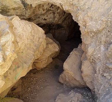
Peppersauce Cave is a primitive ‘at own risk’ site with no services. It is located 2.2 miles south of the Peppersauce Campground on Mount Lemmon Road. The road abruptly turns left there. A short distance up the wash is the cave’s sign.
Cave Map (Facebook) | SkyAboveUs | Wikipedia Article | On Google Maps | Wild Tours
Mount Lemmon Road | FR 38

Mt. Lemmon Road goes from Oracle to the Summerhaven resort. The road is Control Road #38 within the Coronado National Forest with the top five miles being more primitive and rocky. It goes up to a cooler 7,800′ or so in elevation to Summerhaven’s restaurants, shops, lodging and Mt. Lemmon Ski Valley with it’s sky ride. Parts of the road might be closed when there are winter storms or possible washouts.
Getting there from San Manuel: Go NW about 8/10 of a mile (from gas station) on Veterans Memorial Blvd and turn left onto Webb Road and go 6 miles. At the T, turn left onto Mount Lemmon Road. learn more
Redington Road From Tucson

San Manuel makes a nice restaurant lunch stop on this primitive road excursion. Going east on Tanque Verde Road in Tucson it becomes Redington Road as Forest Road #371 that takes you northeast to near Redington then on to San Manuel where it becomes Veterans Memorial Blvd. Pavement begins in Pinal county at the county line onward to San Manuel. Veterans Memorial Blvd then continues NW five miles to Highway 77 that toward Tucson becomes Oracle Rd.
Southern Arizona Guide Article | Friends of Redington Pass | Hunting Info
Road To Benson

The route between Benson and San Manuel is paved on both ends but in-between is about 27 miles of unpaved road. It has narrow and curvy sections and can be rough (especially at washes). learn more
Bicycling

There’s lots of scenery to include San Manuel in a bike ride or mountain biking trek. Annually the Santa Catalina Weekend races are based out of San Manuel. And, one cyclist course of the Mt Lemmon Gravel Grinder passes through San Manuel. | San Manuel Cycling Trails